BETHESDA

WHAT YOU'LL SEE!
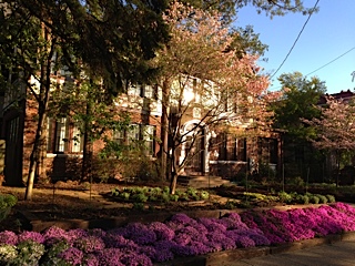
Bethesda is one of the most affluent and highly educated communities in the country, placing first in Forbes list of America's most educated small towns and first on CNNMoney.com's list of top-earning American towns. Forbes ranked Bethesda second on its list of "America's Most Livable Cities." Total Beauty ranked Bethesda first on its list of the U.S.'s "Top 10 Hottest-Guy Cities."
HISTORY
A small settlement grew around a store and tollhouse along the Washington and Rockville turnpike. By 1862, the community was known as "Darcy's Store" after the owner of a local establishment, William E. Darcy. The settlement was renamed in 1871 by the new postmaster, Robert Franck, after the Bethesda Meeting House, a Presbyterian church built in 1820 on the present site of the Cemetery of the Bethesda Meeting House. The church burnt in 1849 and was rebuilt the same year about 100 yards south at its present site.
Throughout most of the 19th century, Bethesda was a small crossroads village, consisting of a post office, a blacksmith shop, a church and school, and a few houses and stores. It was not until the installation of a streetcar line in 1890 and the beginnings of suburbanization in the early 1900s that Bethesda began to grow in population. Subdivisions began to appear on old farmland, becoming the neighborhoods of Drummond, Woodmont, Edgemoor, and Battery Park. Further north, several wealthy men made Rockville Pike famous for its mansions. These included Brainard W. Parker("Cedarcroft", 1892), James Oyster ("Strathmore", 1899), George E. Hamilton ("Hamilton House", 1904; now the Stone Ridge School), Luke I. Wilson ("Tree Tops", 1926), Gilbert Grosvenor ("Wild Acres", 1928–29), and George Freeland Peter ("Stone House", 1930). In 1930, Dr Armistead Peter's pioneering manor house "Winona" (1873) became the clubhouse of the original Woodmont Country Club (on land that is now part of the National Institutes of Health (NIH) campus). Merle Thorpe's mansion, "Pook's Hill" (1927, razed 1948) — on the site of the current neighborhood of the same name — became the home-in-exile of the Norwegian Royal Family during World War II.
That war, and the expansion of government that it created, further fed the rapid expansion of Bethesda. Both the National Naval Medical Center (1940–42) and the NIH complex (1948) were built just to the north of the developing downtown. This, in turn, drew further government contractors, medical professionals, and other businesses to the area. In recent years, Bethesda has consolidated as the major urban core and employment center of southwestern Montgomery County.[6] This recent growth has been significantly vigorous following the expansion of Metrorail with a station in Bethesda in 1984. Alan Kay built the Bethesda Metro Center over the Red line metro rail which opened up further commercial and residential development around the surrounding vicinity.
GEOGRAPHY
According to the United States Census Bureau, the CDP has a total area of 13.2 square miles (34 km2). 13.1 square miles (34 km2) of it is land and 0.1 square miles (0.26 km2) of it (0.38%) is water. The main commercial corridor that runs through Bethesda is Maryland Route 355 (known as Wisconsin Avenue in Bethesda and as Rockville Pike and Hungerford Drive in more northern communities), which, to the north, connects Bethesda with the communities of North Bethesda and Rockville, ending, after several name changes, in Frederick, Maryland. Toward the South, Rockville Pike becomes Wisconsin Avenue near the NIH Campus and continues beyond Bethesda through Chevy Chase, Friendship Heights, Maryland and into Washington, DC, ending in Georgetown.
The area commonly known as "Downtown Bethesda" is centered at the intersection of Wisconsin Avenue, Old Georgetown Road and East-West Highway. Other focal points of downtown Bethesda include the Woodmont Triangle, bordered by Old Georgetown Road (Maryland Route 187), Woodmont and Rugby Avenues, and the Bethesda Row, centered at the intersection of Woodmont Avenue and Bethesda Avenue. Much of the dense construction in that area followed the opening of the Bethesda station on the Red Line of the Washington Metro rapid transit system, also located at this intersection and the centerpiece of the Bethesda Metro Center development. The Medical Center Metro stop lies about 0.7 miles north of the Bethesda stop, Medical Center, which serves the NIH Campus, the Walter Reed National Military Medical Center, and the Uniformed Services University of the Health Sciences.
DEMOGRAPHICS
Bethesda is a very wealthy and well-educated area. According to the 2000 Census, Bethesda was the best-educated city in the United States of America with a population of 50,000 or more. 79% of residents 25 or older have bachelor's degrees and 49% have graduate or professional degrees. According to a 2007 estimate, the median income for a household in the CDP was $117,723, and the median income for a family was $168,385. Males had a median income of $84,797 versus $57,569 for females. The per capita income for the CDP was $58,479. About 1.7% of families and 3.3% of the population were below the poverty line, including 1.8% of those under age 18 and 4.1% of those age 65 or over. Many commute to Washington D.C. for work. The average price of a four bedroom, two bath home in Bethesda in 2010 was $806,817 (which ranks it as the twentieth most expensive community in America).
Bethesda is often associated with its neighboring communities, Potomac, Maryland, Chevy Chase, Maryland, Great Falls, Virginia, and McLean, Virginia for their similar demographics. In 2009, Self magazine ranked Bethesda as the second healthiest place for women in the country, a year after being ranked number one. As of 2009, 8 Pulitzer Prize winners live in Bethesda, as do several well-known political commentators (including George Will, David Brooks, and Tom Friedman).
This information provided courtesy of Wikipedia.


